There are two archipelagoes under the sovereignty of India i.e. Andaman & Nicobar and Lakshadweep. Archipelagoes refers to a group of islands. These islands of India are located in the India ocean. These island are very important economically, environmentally and strategically. A student of geography should know about the process of formation of these islands and geographical fact about them. Let us discuss them in detail.

Andaman and Nicobar Islands
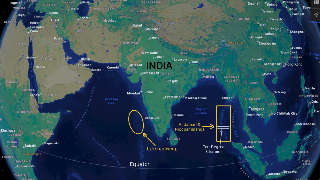
- Andaman and Nicobar islands are situated in Indian Ocean just north of equator (Fig. 1) in Bay of Bengal.
- In fact, Andaman and Nicobar are two separate groups of islands.
- A long narrow water body (strait) called Ten Degrees Channel separates these island groups. Anyway, both these island groups are a single Union Territory of India.
- Port Blaire is its capital city.
- Landfall island is its northern most point whereas Indira point is the southernmost point of Andaman and Nicobar islands.
- According to official website of Andaman and Nicobar union territory, there are a total of 836 islands out of which only 31 islands are inhabited having population of 434192 in 2019.
- The islands have an area of 8249 km² with 03 districts and 09 tehsils.
- People: Originally, these islands were home to many indigenous tribes such as Jarawa, Sentinelese, Onge etc. However, many people from Indian mainland migrated to these islands under British rule. Some of the islands are uninhabited.
- Climate: Since, the Andaman and Nicobar islands are very close to equator, they experience high annual average temperature and rainfall.
- Flora: Since the islands are very close to equator, they have very dense evergreen rainforests, therefore, most of them are under the protection of Wildlife Act, 1972. Andaman Redwood or Narra, Nicobarese ferns and mangrove forest are the dominant types of vegetation in these islands.
- Fauna: Andaman wild pigs, macaques, civets, spotted deers, shrews, whales, dolphins and dugongs are important land and marine animals of these islands.
Formation of Andaman and Nicobar Islands
Earth’s crust is not one single layer but a combination of many landmasses. We term these different landmasses as plates.
- There are many major and minor plates of earth’s crust. They share boundaries with each other.
Some of them converge, some diverge and some just slide past each other. - The Indian plate is a major plate and share boundary with Burma plate which is a minor plate. The Indian and Burma plates are converging which caused the crust to fold and form submarine mountains.
- In fact, these islands are continuation of Arakan Yoma mountains on Indo-Burma border. Andaman and Nicobar islands are peaks of those mountains which are visible above sea surface.

Lakshadweep Islands
- Lakshadweep islands are also known as Laccadive Islands. The name of islands simply translates to lakhs of islands. Kavaratti is the capital of Lakshadweep islands.
- These are located about 300 kms west from the coast of Kerala in Arabian Sea.
- According to official website of Lakshadweep Islands, there are 36 islands having an area of 32.69 km² in this union territory. However, people live on only 10 of those islands.
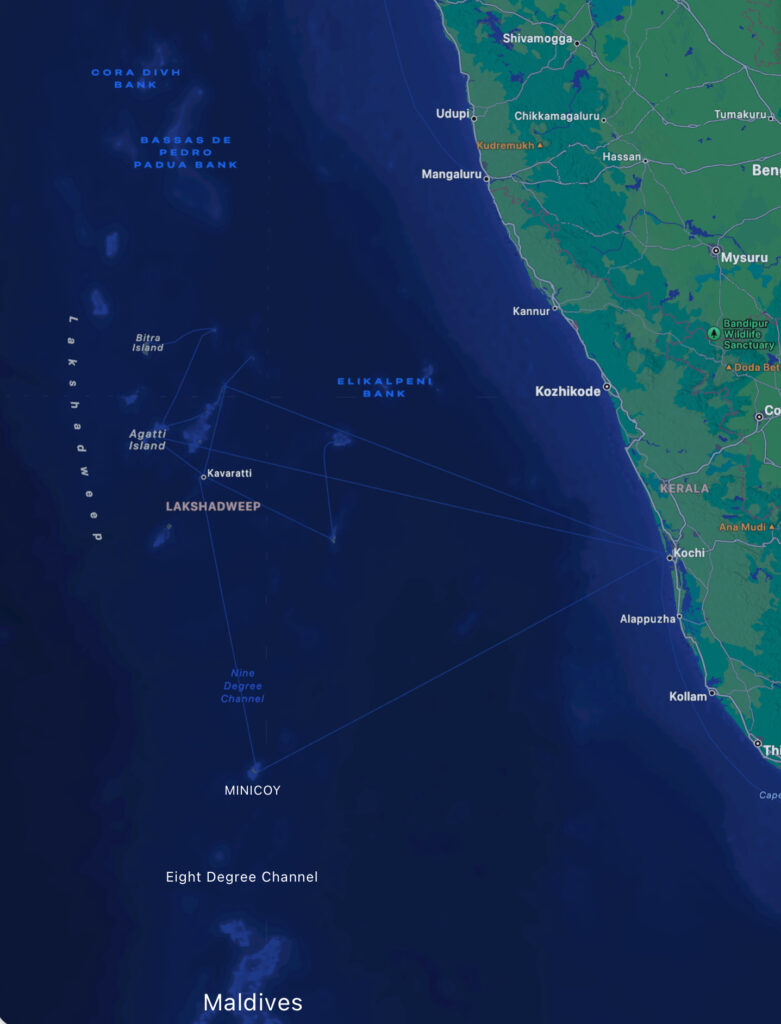
- There are two major groups of islands in Lakshadweep i.e Amindivi and Minicoy islands in north and south, respectively.
- Nine Degree Channel separates Amindivi islands from Minicoy (Fig.2).
- People: Most of the people in these islands are Dravidians and speak Malayali language and profess Islam religion.
- Climate: These islands have equatorial climate with high rainfall and temperature due to its proximity with equator. Cyclonic activities affect the weather in Lakshadweep during strong monsoon winds either in summer or winter.
- Flora: The soils in Lakshadweep are generally sandy, therefore, they do not have dense rain forests like Andaman and Nicobar. Anyways coconut and palms trees are found in abundance. Other notable trees of these islands are include casuarinas, screw pines, banyan, tamarind (imli) and tropical almonds.
- Fauna: Due to lesser availability of land and abundance of sea water, Lakshadweep has a lot of marine life. These marine animals include tuna, flying fish, manta ray, octopus, crab turtle. Apart from the sea animals, we can see many water dependent birds like heron, sea gulls, teals etc. in these beautiful islands.
Formation of Lakshadweep Islands
- The Lakshadweep are coral islands.
- Corals are small marine aquatic animals who live in large colonies in shallow seas with abundance of sunlight. They need clear sea water for survival.
- Their bodies are made up of calcium carbonate. When the corals die, the calcium carbonate accumulates in shallow seas.
- The new generation of corals live on mounds made of calcium carbonate left by dead corals. This process repeats over millions of years leading to formation of coral islands.
- The uplifting of sea bed due to plate tectonics, exposes the coral colonies to atmosphere. Ultimately, the corals above sea surface die and leave the islands behind. With time, sea waves deposits sand on these islands.
This same process created Lakshadweep Islands.
Conclusion
From the above discussion, we can conclude that islands of India are one of the most beautiful physiological units of India. These islands are very popular among tourists for their beauty. Geological history and process of formation of these islands has been simplified in this article. However, students should consult good books for detail.
Kulwinder Singh is an alumni of Jawaharlal Nehru University, New Delhi and working as Assistant Professor of Geography at Pt. C.L.S. Government College, Kurukshetra University. He is a passionate teacher and avid learner.
