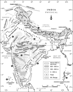
India is a physiologically diverse country. There are five physiological divisions of India i.e. Indo-Gangetic Plains, Plateau, Mountain Ranges, Coastal Plains and Islands. The mountain ranges in India form the third largest physiological unit of India. These mountain ranges were formed during different periods of geological history in different places. Therefore, their altitude, rock structure, origin, vegetation etc. varies a lot. For example, Aravalli mountains are the oldest mountain range in India whereas the Himalayas are the youngest ones but there is a great difference in the altitude and vegetation of these mountain ranges.
Types of Mountains in India
Generally, there are two types of mountains i.e. block mountains and fold mountains. Scientist differentiate them on the basis of their formation and altitude.
Block Mountains
The faulting of earth surface and resultant upward and downward movement of land leads to formation deep troughs and upstanding land masses (Fig. 1).
- The upstanding land masses are called horst or block mountains whereas the deep troughs are called graben or rift valleys.
- With passage of time, the erosion and weathering of sharp corners of horst provide them a typical hilly appearance (Fig. 1).
- These mountains have a lower altitude in comparison to the fold mountains.
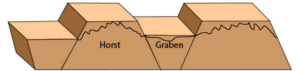
Fig. 1: Faulting, Horst and Graben
The major block mountains of India are as follows.
1. Vindhya Range:
- These mountain ranges lies in the central India and runs parallel to right bank of Narmada river and Indians treat it as an informal boundary between north and south India.
- Vindhyas acted as a major barrier against trade, migration and conquest between north and south in past times.
- Kaimur hill range is a part of Vindhyas and extends up to Sasaram in Bihar.
2. Satpura Range
- The second important block mountain range is Satpura Hills with an elevation between 600-900 meters above sea level.
- It is most famous for its dense forests having thick growth of shrubs and intertwined lianas and vines.
- These ranges lie between Narmada and Tapti rivers in east-west direction.
- Mahadeo and Maikal hills are the extension of Satpura range up to Jharkhand.
3. Ajanta Hill Range
- The Ajanta hill range runs parallel to Tapti river on its left bank in east-west direction.
- Its elevation varies between 600-900 meters.
Formation: Please note that the Vindhya, Satpura and Ajanta ranges formed due to three episodes of faulting during Proterozoic Period. In fact, the parts of Gondwanaland broke and assembled many times during that period. On each assembly, the rocks experienced tensional force which lead to faulting.
4. The Western and Eastern Ghats
- These western and eastern Ghats are the hills having an altitude ranging from 600 to 2000 meters.
- Anaimudi is the highest peak in western ghats whereas Mahendergiri is the highest peak in eastern ghats.
- Venukonda, Nalkonda, Nagari, Javadi, Shevroy, Panchamalai, Sirumali and Palani are the hilly regions of western ghats as they lie from north to south direction.
- Formation: The western ghats were formed due to formation of a long fault parallel to the India’s western shoreline. The western part of the peninsula started rising and triggered the formation of numerous small and medium faults in the peninsula. This faulting activity took place due to isostatic adjustment during Tertiary period and probably resulted from the collision of Gondwanaland with Eurasian plate in Tertiary period. The formation of Eastern Ghats took place during Archeon Eon (2.9 billion years ago). The Eastern ghats are relic mountains of a very old mountain ranges. These are much older than the Western ghats.
Fold Mountains
The tectonic activity on earth also leads to the formation of fold mountains. However, the mechanism of their formation is different from the block mountains. The fold mountains form due to drifting of continents (see Continental Drift Theory).
Formation of Fold Mountains: Generally, either two continental plates collide with each other or the continental plate collides with oceanic plate to form large folds in earth’s crust. For instance, the formation of Himalayan Mountains took place due to collision of two continental plates i.e. Gondwanaland and Laurasia plate. Similarly, the Rockies and Andes mountains were formed due to collision of Pacific ocean plate with North and South America, respectively. In the former case, the both the continental plates remain on surface. In the latter case, the continental plate overrides oceanic plate and pushes the oceanic plate in asthenosphere. Himalayas and Aravalli Mountains are examples of fold mountains. However, Aravalli ranges are only the relics of their former self. Guru Shikhar is its highest peak with an altitude of 1722 meters from sea level.
The Himalayan Mountain Ranges
Contrary to Aravalli Mountains, Himalayas are humongous cordilleras with an average altitude of 6000 metres and length of 2400 Kilometres. It occupies approximately 5 lakhs square kilometres of area in Indian subcontinent. Most of the rocks in Himalayas are Sedimentary rocks which has been metamorphosed by intense pressure exerted by collision of Gondwanalamd and Laurasia. Generally, we can divide Himalayas into four categories i.e. Outer Himalaya, Lesser Himalayas, Greater Himalayas and Trans Himalayas.
1. Outer Himalayas or Shivalik Hills
The Shivalik Hills are the lowest mountain range in Himalayas with an altitude of 600-1500 meters. They run on the southern most margin of Himalayas from Jammu & Kashmir to Arunachal Pradesh. It is the Brahmaputra which is believed to have eroded most of the Shivalik Hills over thousands of years. Darla, Miri and Abor Hills are some part of Shivalik which is still intact in Arunachal Pradesh. The Shivalik are made up of sand, clay, sandstone and conglomerates. There are inter-montane plains in these hills called duns e.g. Dehradun, Kotlidun and Patlidun.
2. Lesser Himalayas or Middle Himalayas
These mountains of Himalaya has an average altitude of 3000-4500 metres and are home to many hill stations like Shimla and Manali. It is known as Pir Panjal in Kashmir and Dauladhar in Himachal Pradesh.
3. Greater Himalayas or Himadri
The Great Himalayas are the highest of all the Himalayan mountains with an average altitude over 6100 meters. They contain the highest peaks of the world remains under snow during most of the year. The Mt. Everest, Kanchenjunga, Makalu and Dhaulagiri are some of the famous mountain peaks. Continuous global warming is leading to melting of Himalayan glaciers and their ultimate retreat.
4. Trans-Himalayas
After crossing the main ranges of Himalayas, we come across Trans-Himalayan ranges. These are Zanskar, Ladakh and Karakoram as we move from south towards the north. Kailash mountain Ranges fall in Tibet. K2 or Godwin Austin is the highest peak of Trans- Himalayas. These ranges fall in the rain shadow zone therefore most of the trans-Himalayan region is cold desert.
5. Purvanchal
These are the hills located in northeastern India on the east side of Dihang gorge. They have local names such as Patkaibum in Arunachal Pradesh, Naga Hills in Nagaland, Mizo Hills in Mizoram.
Contrary to popular belief, Garo, Khasi and Jaintia Hills in Meghalaya, are not part of Himalayas but part of peninsular plateau.
Conclusion
From the above discussion, we can discern than India has a very complex geological history. Therefore, it is very difficult to discuss to understand the formation of all relief features of India in one article. However, this article give us a broad idea about the formation, location and geological characteristics of mountain ranges in India.
Kulwinder Singh is an alumni of Jawaharlal Nehru University, New Delhi and working as Assistant Professor of Geography at Pt. C.L.S. Government College, Kurukshetra University. He is a passionate teacher and avid learner.