Temperate cyclone is rotating weather system which is formed in mid-latitudes. Frontal Cyclones, mid-latitude depressions, extra-tropical cyclones are all synonyms of temperate cyclone. They derive their name from temperate climates which exist in the mid-latitudinal zone i.e. 30° to 60°latitudes. It is this zone where the warm tropical air mass meets the cold polar Air Mass. The temperate cyclones are quite different from the Tropical Cyclones in terms of their characteristics and origin.
Types of Air Masses and Fronts
Let us first understand the few important concepts linked to temperate cyclones. These concepts will enable us to understand the theories of formation of temperate cyclones in a more lucid manner.
- Air Mass: An air mass is a huge body of air having homogeneous temperature and moisture (humidity) conditions over a large area. The polar air masses are cold, the tropical air masses are warm, the continental air masses are dry and maritime air masses are humid. For detailed knowledge, Click Here.
- Fronts: in simple words, a front is the boundary between two adjoining air masses having different temperature and moisture content. According to Oliver and Hidor, front is “a zone of transition between air of different properties”. Fronts are of three types.
- Warm Front: In the simple world, we term a front as a warm front when the warm air is pushing forward and cold air mass is relatively less active. The location of warm front is usually on the eastern side of the cyclone in northern hemisphere and on the western side in the southern hemisphere. On the warm front, we can observe greater wind speed, cloudy sky, more humidity and rainfall than the cold front.
- Cold Front: We term a front as a cold front when the cold air is pushing forward and warm air mass is, relatively, calm. The location of cold front is usually on the western side of the cyclone in northern hemisphere and on the eastern side in the southern hemisphere. On the cold front, the wind speed is low, sky is clear, air is dry and rainfall is negligible.
- Occluded Front: This front is formed when the cold air mass pushes the warm air mass away from the ground. Therefore, the boundary between cold and warm air mass does not stay in contact with ground. The whole ground is covered with cold air mass. Formation of occluded fronts points towards dissipation of temperate cyclones.
Characteristic of Temperate Cyclone
- They form due to collision of polar air masses with tropical air masses. The warm winds from tropical regions are called Westerlies and the cold winds from the poles are called the Polar Easterlies.

Fig. 1: Formation of Temperate Cyclones; Source: Strahler and Strahler, 5th Edition - The primary location of their origin is mid-latitudes i.e. 35° to 65°latitudes.
- The influence of these cyclones may vary from 500 to 2500 Kms.
- Although temperate cyclones form throughout the year but they more violent in the winter season because polar easterlies become much stronger during winter. Additionally, the temperature difference between polar and tropical air mass is larger during winter than the summer.
- The velocity of winds in these cyclones are much lower than the tropical cyclones because the pressure gradient is low.
- The rotating air in the temperate cyclone does not have homogeneous temperature and moisture properties. One of the sectors of a temperate cyclone is the cold sector with calm, cold and dry weather. The other sector is the warm sector with windy, warm and moist weather. The warm sector lies in the southeastern part of the cyclone in the northern hemisphere.
Polar Front Theory of Cyclone Formation
Polar front theory is the most popular and accurate theory which explains the origin, development and dissipation of temperate cyclones in an orderly manner. V. Bjerknes and his son J. Bjerknes were the leading Norwegian meteorologists who developed this model. Therefore, this model is also called the Norwegian Model or Wave Theory. According to this model, there are five stages of frontal cyclone formation.
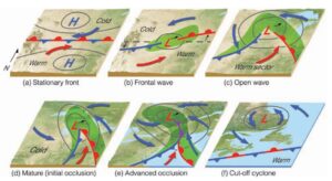
Stage I: Stationary Front
- In this stage, the polar cold air mass and tropical warm air mass are stationary and do not push each other. It is primarily because the difference in temperature and moisture properties of the two air masses is not sufficient to create instability at the boundary of these air masses [See Fig. 2 (a)].
- In the later phase of this stage, difference in the temperature and moisture arises due to many climatic factors such as differences in insolation, evaporation, invasion by hot or cold winds, heat loss through conduction, convection or radiation etc.
- As the difference between two air masses increases, they start to push each other.
Stage II: Frontal Wave
- In theory, the subtropical winds should blow towards the north direction and the polar easterly wind should blow towards the south direction. Since both these winds experience Coriolis force, they turn to the right. Hence, northward blowing subtropical winds blow towards northeast as subtropical westerlies and southward blowing polar winds blow toward the southwest as polar easterlies.
- When these winds meet, they form cyclonic fronts. Due to the Coriolis effect, the warm air mass is more active on the eastern side and forms a warm front in northern hemisphere. Contrarily, the cold air mass is more active on the western side and forms a cold front [see Fig. 2 (b)].
- The contestation between the easterlies and westerlies in presence of Coriolis force morphs the straight frontal boundary into a wave .
- Further, the cold air pushes the warm air upward leading to condensation of moisture in the warm air mass. As a result, precipitation takes place.
- Due to condensation, the latent heat from the water vapor is released in the atmosphere. The latent heat further heats the air leading to formation of a strong low pressure zone. Therefore, the air pressure difference increases between the air masses and cold air invades the warm sector aggressively.
- In the end of this stage, the warm sector shrinks and the cold sector grows larger. The shape of the boundary looks like an wave.
Please note that the author is explaining this theory in the context of the northern hemisphere. The Coriolis force in the southern hemisphere works in opposition to the northern hemisphere. Therefore, all the cyclonic processes in the southern hemisphere are completely opposite of the northern hemisphere.
Stage III: Open Wave
- We read that in the second stage, the release of latent heat creates a low pressure zone or atmospheric depression at the warm front. This process of pressure differentiation between warm and cold air mass intensifies in the third stage which creates a high pressure gradient.
- The winds or air blowing towards the low pressure zone experience Coriolis force and a counterclockwise rotation starts.
- The warm air in the low pressure zone rises upwards which further attracts the winds from surrounding regions.
- Since, the cold air is heavy, it continues to push along the cold front and the warm air starts to rise along the inclined front. therefore, separate warm and cold sectors form. The wave takes the shape of an inverted-V [see Fig. 2 (c)].
- The supply of latent heat through condensation starts to decline.
- The warm and cold front come in proximity to each other.
Stage IV: Beginning of Occlusion
- In this stage, the cold front continues to push the warm air away from the ground.
- The warm sector shrinks further and both fronts merge. The war sector vanishes from the ground.
- Thereafter, the supply of latent heat from the moisture declines to a low level. The velocity of winds declines too.
- At the end of this stage, the cold air mass lifts the warm air mass completely off the ground. The merged front is suspended in the air and is called the Occluded Front [see Fig 2 (d)].
Stage V: Occlusion
- Ultimately, the cold air completely pushes the warm air off the ground. As a result, the warm air temperature declines due to adiabatic cooling.
- Hence, the atmospheric stability is restored at the fronts.
- The front becomes straight, again [see Fig 2 (e)].
Lastly, some war air is separated from the warm air mass is end up in cold air mass. Therefore, weak cyclonic activity continues in the cold air mass for sometime but it ultimately dissipates[see Fig 2 (f)].
Conclusion
To sum up, we can say that the temperate cyclone is a weather phenomenon which originates due to differences in the temperature and moisture conditions of air masses. This instability results in rotation of winds and leads to rainfall, snowfall, thunder and lightning. As soon as the warm air cools due to adiabatic lapse rate, the temperate cyclone starts to dissipate.
Reading List
- Ahrens, C. D., Meteorology Today, 9th Edition (2009)
- Atmosphere, Weather and Climate (9th Edition), Barry and Chorley (2010), Routledge Publication, Taylor and Francis Group
- Physical Geography, Strahler and Strahler (2011), John Wiley & Sons Publication
Kulwinder Singh is an alumni of Jawaharlal Nehru University, New Delhi and working as Assistant Professor of Geography at Pt. C.L.S. Government College, Kurukshetra University. He is a passionate teacher and avid learner.