Cyclones are one of the most hazardous atmospheric events. Therefore, disaster management authorities have to issue early warning to the public, take risk reduction measures, prepare rescue strategies and plan rehabilitation before such events occur. Hence, disaster managers must know the types of cyclones, their origin and characteristics. Cyclones are primarily of two types i.e. tropical cyclones and temperate cyclones.
Characteristics of Tropical Cyclones
- Definition: The cyclones which originate on warm sea surfaces between the tropic of cancer and Capricorn are called tropical cyclones. The tropical cyclones are a single rotating mass of air with uniform temperature and moisture.
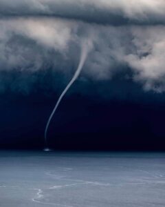
- They are called Hurricanes in North America (around Caribbean Coast), Typhoons in China, Taifu in Japan, Baigio in Phillipines and Willi Willies in Australia. Tornado is also a cyclone but it looks like a funnel covering a very small area in comparison to cyclones. Like cyclones, Tornadoes are also very destructive (Fig. 1).
- The cyclones rotate counter-clockwise in the northern hemisphere and clockwise in the southern hemisphere (see Fig. 2).
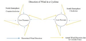
Fig. 2: Cyclone Rotation in North and South Hemisphere - The wind speed in tropical cyclones reaches greater than 150 Kms.
- The winds revolve around a small zone of very low atmospheric pressure which is known as the Eye of cyclone. Eye is the zone of very calm weather with clear sky and no rainfall.
- A vertical veil of very high speed winds revolve around the eye of the cyclone which is termed as Eye Wall. The winds in the eye wall are the most destructive winds in the cyclone. These winds rotate while rising upwards (see Fig. 1).
- A very thick layer of clouds rotate above the cyclone except the eye.
- Landfall is the time when the eye of cyclone enters land surface from the sea surface.
- They shower widespread rainfall over affected areas along with thunder and lightning.
- They originate over sea surfaces and die out inland from the sea shore.
- Any obstacle on the path of cyclones get destroyed. Therefore, it destroys infrastructure, flora, fauna, changes the paths of rivers and floods the coastal areas with storm surge.
Conditions for Tropical Cyclones
Tropical cyclones need many suitable conditions for their generation. These conditions are as follows.
- Tropical Cyclones originate on warm sea surfaces with a temperature of 26⁰C up to a depth of 150 feet. The Sun in a hot summer provides such a level of insolation to the sea surface. The ocean water continuously provides energy to cyclones in the form of latent heat.
- The hot sea surface water provides moisture and heat to the air above it. Therefore, the air becomes highly unstable and a strong updraft of air starts. This updraft of air is also known as convection currents.
- The low value of wind shear helps to start the rotation of winds. Wind shear is the change of speed of winds with increasing height. If the wind speed continues to grow with height, it will hamper the convective currents of air. Therefore, the cyclone may be eliminated in its infancy.
- The rotational force of the winds come from Coriolis Force. The Coriolis force is nil near the equator. Therefore, the tropical cyclones never originate between the 5° north and 5° south latitudes but outside the equatorial belt.
- Anticyclonic conditions in the upper troposphere helps to strengthen the cyclones. Anticyclone refers to a high atmospheric pressure zone. The winds blow outwards from the high pressure zone. In opposition to the cyclone, the winds in the anticyclone blow clockwise and counter-clockwise in the northern and southern hemisphere, respectively.
- A pre-existing atmospheric depression or remnant of a larger cyclone may help in forming a new cyclone. For instance, if a typhoon from the North China sea weakens and reaches Bay of Bengal, it may gain strength again and become a tropical cyclone.
Cyclogenesis of Tropical Cyclone
- Cyclogenesis is the process of formation of cyclones. The tropical cyclone originates over the sea surface as mentioned below.
- Initially, continuous solar radiation raises the temperature of surface water of the sea up to a depth of 150 feet.
- The water from the sea surface starts to evaporate due to continuous influx of solar radiation. The transfer of heat from sea water to air through conduction and evaporation makes the air warm and moist. Since, warm and moist air is light, it starts to rise up. These streams of rising warm and moist air are called convection currents.
- While rising, the water vapor in the air condenses and releases latent heat in the middle troposphere (4-5 Kms. of altitude). The latent heat makes the surrounding air warmer and lighter, therefore, it continues to rise up.
- Since, the updraft of air is leaving an empty space at sea surface, the atmospheric pressure drops and the surrounding air rushes to fill in that empty space. The fresh air also becomes warm and moist and starts rising. This moisture in the updraft of air continues to condense at Dry and Moist Adiabatic Rate leading to greater cloud cover.
- Please note that the air, which rushes in to fill the empty space left by rising warm air, does not flow towards the low pressure zone in a straight line. It curves to its right in the northern hemisphere and to its left in the southern hemisphere. This curvature makes the winds rotate clockwise and counter-clockwise in the north and south hemisphere, respectively (see Fig. 2).
- The low pressure in the eye of the cyclone along with high velocity winds in the eye wall causes the sea water to rise 15-20 feet higher than the mean sea level. This surge of water travels with the cyclone and strikes the coast at the point of landfall and causes widespread flooding. This phenomenon is called Storm Surge.
- Ultimately, due to absence of other atmospheric disturbances, the whole system starts to rotate and forms a cyclone (Fig. 3).
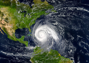
Fig. 3: Cyclone from Space in Caribbean Sea
Path of the Tropical Cyclone
The tropical cyclones generally move westward between 5° and 15° latitudes due to the influence of easterly winds in the tropics. However, under the Coriolis force they turn towards the poles around 18°-20° latitude. The Coriolis force increases poleward, therefore, the northward moving cyclone curves further towards the east around 25° latitude.
In India, the cyclones in the Bay of Bengal generally move westward and northward and make landfall on the East Coast of India in states of West Bengal, Orissa, Andhra Pradesh and Tamil Nadu. The cyclone in Arabian Sea move westward, then turn northward. Sometimes, the northward moving cyclones turn east ward around 23-25° latitude and bring havoc in coastal areas of Gujarat and Maharashtra.
Dissipation of Cyclone
The rising air condenses and showers rain over the affected areas. Thereafter, the air becomes dry and cool. Some of this dry and cool air subsides in the eye of the cyclone while the rest subsides around the cyclone. This process continues till the warm water continues to supply water moisture to the cyclone. As soon as the cyclone makes the landfall, its energy starts to decline. Ultimately, the cyclone dissipates.
Conclusion
To sum up, we can conclude that a cyclone is a very destructive natural atmospheric event. Humans have no remedy to stop it, however, early warning systems, disaster resilience, risk reduction, rescue and rehabilitation can reduce the impact of cyclones on economy and ecosystem.
Kulwinder Singh is an alumni of Jawaharlal Nehru University, New Delhi and working as Assistant Professor of Geography at Pt. C.L.S. Government College, Kurukshetra University. He is a passionate teacher and avid learner.