Northern plains of India or Indo-Gangetic plains form the second largest physiological division of India with an approximate area of 21 percent of the total geographic area of India. The Ganga, Indus and Brahmaputra flow through these plains and provide plenty of water for irrigation. Hence it is, agriculturally, the most fertile land in India and forms the backbone of economy of rural India.
Formation of Northern Plains of India
The formation of these plains is closely linked to the formation of Himalayan Mountains.
- About 66 million years ago in Tertiary Period, the Gondwanaland started moving northward towards Laurasia.
- The ocean between these two landmasses started to become narrow. This water body is termed as Tethys sea by geologists.
- Corresponding to the narrowing of Tethys, the rivers from Gondwanaland and Laurasia deposited sediments in the Tethys. Over time, Tethys became narrow and shallow. This narrow elongated shallow sea is called geosyncline
- The compressional force from movement of Gondwanaland and Laurasia lead to folding of sediments in the geosyncline. Slowly, the Tethys completely vanished due to deposition and uplifting of landmass.
- The folded part of the geosyncline came to be known as Himalayas whereas the unfolded part of geosyncline is known as Great Plains of North India. The process of folding of Himalayas is still ongoing.
- Also read, Continental Drift Theory for better understanding.
Physiological Division of Indian Plains
- A river is young and vibrant in the hilly region but loses its energy instantly as soon as it enters the plain region.
- Therefore, it can not carry heavy sediments for long distances. The river deposits alluvium in a certain pattern. The river deposits the heavier sediments near the hills whereas it deposits the lighter sediments farther from hills.
- The hundreds of rivers entering plains from Himalayas show the same deposition pattern and lead to formation of elongated regions of sediments of different sizes parallel to Himalayas. Let us learn about these regions as following.
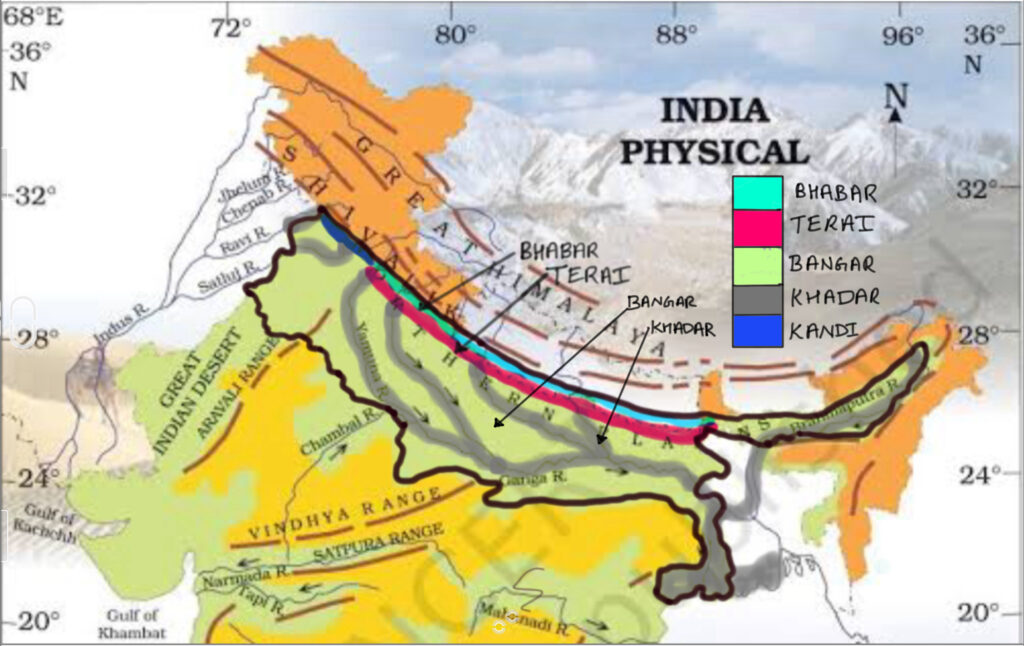
Bhabar
- Bhabar is the first belt of sediments along the foothills of Himalayas. Its runs along foothills of Himalayas and has a width of 8-16 kms (Fig. 1 & 2).
- It consists of coarse and heavy sediments which can not be transported by river farther from mountains as it looses energy.
- These sediments consist of pebbles, boulders, coarse sand and fragments of rocks. There is lots of space between the boulders and pebbles through which river continues to flow but disappears from the surface.
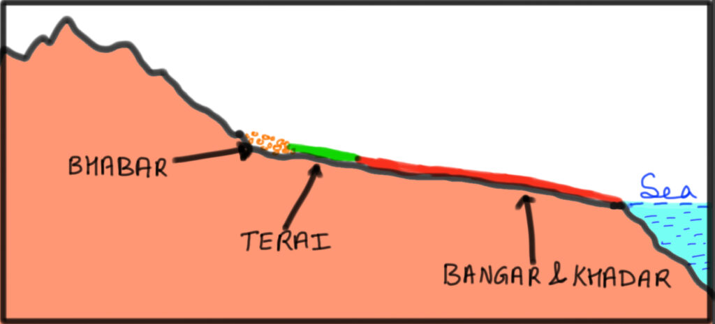
Terai
- Terai lies to the south of Bhabar as seen in Fig. 1.
- After the zone of coarse sediments, the river water re-emerges on the surface but does not have a defined channel. Therefore, the river water is divided into many small channels and spreads on the alluvial soils. The spread of water on alluvial soils leads to formation of swamps and peatlands.
- Terai is known as duar or dooar in Assam and Northern West Bengal.
- Naturally , such areas do not support agricultural activities but farmers have improved these lands using modern inputs and machines.
- Please note that Punjab and Haryana does not have either the Bhabar or Terai near their mountains. Instead, they have rolling sub-mountainous region intersected by thousands of seasonal rivers. This region is called Kandi.
Bangar
- Unlike Bhabar and Terai, the Bangar and Khadar do not accumulate parallel to Himalayas.
- Bangar is old alluvial soil and lies higher than the flood plains of the river.
- In fact, the plains have experienced uplifting due to collision of Gondwanaland and Laurasia. This uplifting leads to river rejuvenation and deepening of river valley in mountain as well as plains. Thereafter, the river could not reach uplifted plains, hence the new alluviums could not be deposited. The scientists termed these plains of old alluvium as Bangar.
- The Bangar are fertile plains and safe from annual floods, therefore agricultural activities blossom on these plains. However, irrigation is necessary for better yield.
- One can also find intermittent calcareous deposits in Bangar which is known as kankar. The kankar impedes the agricultural yield but the farmers can use limestone to treat alkalinity of soils.
Khadar
- Khadar is the part of indo-Gangetic plains which receive new alluviums from flooding of rivers. Therefore, Khadar is found only in the flood plains of river (Fig.1). These areas lie adjacent to river banks.
- The floods rejuvenate the fertility of these soils. Farmers sow crops with high water demand in these plains e.g. paddy.
- The alluviums in Khadar are very fine in texture e.g. clay and silt.
Regional Division of Indian Plains
The regional geographers classify the Indian plains into different regions based on physiological characteristics, slope of landscape, soil moisture etc. These are as follows.
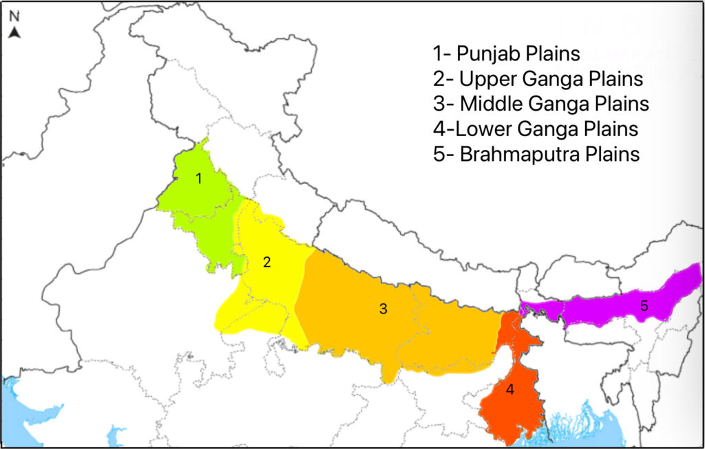
Punjab Plains
Punjab and most of Haryana forms the Punjab plains and the Yamuna river forms its eastern boundary.
- The tributaries of Indus i.e. Ravi, Beas and Satluj flow through these plains.
- The soils are predominantly alluvial but has higher content of sand than Gangetic plains due to semi-arid climate. Since, the soils in Punjab plains has better drainage, it was easy to implement green revolution in these plains during 1960s.
- The Punjab contains two major doabs (land between two rivers) i.e. Bari and Bist Doab. Bari Doab is plains between Beas and Ravi rivers. Bist Doab is the land between Beas and Satluj rivers.
- South of Satluj lies the Malwa plains of Punjab and Bagar plains of Haryana. Please note than eastern part of Haryana plains is formed by Yamuna river.
- Haryana has a kind of saline soil called Reh. The evaporation of soil water from arid parts of Haryana and Punjab lead to rising of salt minerals to surface from subterranean rocks through capillary action. This action forms reh.
Upper Ganga Plain
The upper Gangetic plains contain the Ganga-Yamuna Doab, parts of Rohilkhand and Agra.
- General slope of these plains is towards south-east.
- These plains contains bhur which are sandy dunes near river bank. In fact, upper Ganga plain is a semi-arid region with monsoon climate. Therefore, it remains dry during summer. In summer, the winds blows the sand from river beaches and accumulates near the banks of rivers.
- Due to availability of irrigation, the agriculture is highly productive in this region.
Middle Ganga Plain
Middle Ganga plains include the central UP, eastern UP and parts of Bihar up to the confluence of Ganga, Son and Ganga rivers near Patna.
- These plains have low level of coarse sediments and greater amount of silt and clay than the upper Ganga plains.
- The general slope of plains is towards the east.
- The soils in these plains are very fertile and river water irrigation is readily available.
Lower Ganga Plain
The plains from Patna to Sundarban delta is called lower Ganga plains.
- The general slope of these plains is towards the south. However, the slope of certain tributaries of Ganga such as Son river is towards the north. Similarly, Subarnrekha and Damodar flows from Chhotanagpur towards south and southeastward.
- These plains are very fertile and rich in clay and loam.
- Since the rain and water is abundant, three crops of rice can be cultivated in this region. For example, West Bengal farmers grow Aman, Boro and Aus varieties of rice in a year.
- Many distributaries of Ganga traverses through Sundarbans and frequently change their course. As of result, Sundarbans has a lot of swamps. These swamps have thick growth of mangrove forest and home to Bengal tigers.
Brahmaputra Plains
- The Brahmaputra plains lie mostly in Assam but some of it lies in the northern West Bengal.
- The volume of water in Brahmaputra is greater than the Ganga river.
- It enters India through Dihang gorge and looses its energy as soon as it enters Assam plains. The river suddenly sheds its sediment load.
- As a result, the river channel becomes insufficient to contain the river water. Therefore, Assam experiences widespread flooding in each rainy season.
- In non-rainy season, river forms many distributaries which create braided river plains.
Please note that here, we are treating Rajasthan as a separate physiological entity due to impact of hot climate on its landscape. Otherwise Rajasthan is also a plain region. Additionally, we have not discussed plains of Indus River falling in Pakistan.
Conclusion
In short, we can argue that Indian plains are one of largest plains in the world formed by complex geological processes and riverine action. They are essential for Indian agriculture. Due to human activity, these plains are experiencing a lot of erosion and degradation therefore, we must conserve and restore them for sustainable development.
Kulwinder Singh is an alumni of Jawaharlal Nehru University, New Delhi and working as Assistant Professor of Geography at Pt. C.L.S. Government College, Kurukshetra University. He is a passionate teacher and avid learner.