Agroecological zones are the most reasonable units of planning in India because about 60 percent of the population in India is still dependent on agricultural sector for employment. Any gains in agricultural sector will trickle down to large populace. In this article, we will understand the concept of agroecological zones in context of India.
Definition of Agroecological Zone
An agroecological region or zone is an area of land have homogeneous characteristics related to land suitability, potential production and environmental impact. According to Food and Agricultural Organization (FAO), an Agroecological Zone (AEZ) is a land resource mapping unit, defined in terms of climate, landforms and soils, and/or land cover, and having a specific range of potentials and constraints for land use.
In Simple Words
Basically, the AEZ is a fundamental geographic area which have similar crop combination, crop rotation, temperature, availability of rainfall, irrigation, type of soil, yield, topography and environmental outcomes. These parameters have been explained below in detail.
Crop rotation and Crop Combination
It includes the number and types of crops combinations grown in a particular sequence over an area within a year and over many years. For example, the the farmers in an AEZ can grow wheat, rice and vegetables which is termed as crop combination. Further, the sequence of crops means that which of these crops is grown earlier or later within a year. It also means if farmer grows the different crops on the same piece of land over many years.
Temperature and availability of water
Temperature and water availability through rainfall and irrigation determine the control of farmers on supply of water to the fields. These factors help scientists determine the type of crops which the farmers can grown in an area. It helps planners to decide if farmers should practice dry farming or wet farming.
Soil
It is an important factor for cultivation. An area may have good rainfall and high temperature but it will be difficult to cultivate crops if the soil is not fertile. Some types of soils are really good for certain crops e.g. Black Soil is very good for cotton and sugarcane, the loamy soil is good for wheat etc.
Yield
If all the above factors are suitable, the yield of crop is high and vice-versa. High yield point towards agriculturally developed regions. Yield is also dependent on cropping intensity as explained in Von Thunen Model.
Relief
The variation in altitude from sea level is called relief. For example, mountainous region, plain region, plateau region, coastal plains etc. are different types of relief feature.
Environmental Outcomes
Agricultural practices have certain environmental outcomes which may be positive, negative or neutral. Planner have to determine the net result of cultivation on the environment. This helps the policy makers to understand if present agricultural system is sustainable or not.
In short, agroecological zones/ regions represent the suitability of a cropping system to the given topography and environment in an area. It must be noted that agroecological zones are similar but not the same as agro-climatic zones. Agro-climatic zones one considers agricultural systems in relation to climate but ignores relief of an area.
Agroecological Zones of India
The National Bureau of Soil Survey & Land Use Planning (NBSS&LUP) divided India into 20 AEZs as mentioned below along with their agricultural and environmental characteristics. The respective location has been provided in Map 1.
-
Cold arid ecoregion with shallow skeletal soils
- Geographical Area: 4.70%
- Gross Cropped Area (Million Hectares) : 0.07
- Physiological Region: Western Himalayas
- Precipitation (mm): <150
- Growing Perion (Days): <90
- Major Crops: Vegetables, millets, wheat, fodder, barley, pulses
-
Hot arid ecoregion with desert and saline soils
- Geographical Area: 9.70%
- Gross Cropped Area (Million Hectares) : 20.85
- Physiological Region: Western Plain & Kachch Peninsula
- Precipitation (mm): <300
- Growing Perion (Days): <90
- Major Crops: Millets, fodder, pulses
-
Hot arid ecoregion with red and black soils
- Geographical Area: 1.90%
- Gross Cropped Area (Million Hectares) : 4.18
- Physiological Region: Deccan Plateau
- Precipitation (mm): 400-500
- Growing Perion (Days): <90
- Major Crops: Sorghum, safflower, cotton, groundnut, sunflower, sugar cane
-
Hot semi-arid ecoregion with alluvium-derived soils
- Geographical Area: 9.80%
- Gross Cropped Area (Million Hectares) : 30.05
- Physiological Region: Northern Plain & Central Highlands including parts of Gujarat Plains
- Precipitation (mm): 500-800
- Growing Perion (Days): 90-150
- Major Crops: Millets, wheat, pulses, maize; irrigated cotton & sugar cane
-
Hot semi-arid ecoregion with medium and deep black soils
- Geographical Area: 5.40%
- Gross Cropped Area (Million Hectares) : 11.04
- Physiological Region: Central (Malwa) Highlands, Gujarat Plains & Kathiawar Peninsula
- Precipitation (mm): 500-1000
- Growing Perion (Days): 90-150
- Major Crops: Millets, wheat, pulses
-
Hot semi-arid ecoregion with shallow and medium (dominant) black soils
- Geographical Area: 9.50%
- Gross Cropped Area (Million Hectares) : 25.02
- Physiological Region: Deccan Plateau
- Precipitation (mm): 600-1000
- Growing Perion (Days): 90-150
- Major Crops: Millets, cotton, pulses, sugar cane under irrigation
-
Hot semi-arid ecoregion with red and black soils
- Geographical Area: 5.20%
- Gross Cropped Area (Million Hectares) : 6.19
- Physiological Region: Deccan (Telangana) Plateau & Eastern Ghats
- Precipitation (mm): 600-1000
- Growing Perion (Days): 90-150
- Major Crops: Millets, oilseeds, rice, cotton & sugar cane under irrigation
-
Hot semi-arid ecoregion with red loamy soils
- Geographical Area: 5.80%
- Gross Cropped Area (Million Hectares) : 6.96
- Physiological Region: Eastern Ghats (Tamil Nadu uplands) & Deccan Plateau (Karnataka)
- Precipitation (mm): 600-1000
- Growing Perion (Days): 90-150
- Major Crops: Millets, pulses, oilseeds (groundnut), sugar cane & rice under irrigation
-
Hot sub-humid (dry) ecoregion with alluvium-derived soils
- Geographical Area: 3.70%
- Gross Cropped Area (Million Hectare) : 11.62
- Physiological Region: Northern Plain
- Precipitation (mm): 1000-1200
- Growing Perion (Days): 150-180
- Major Crops: Rice, wheat, pigeon pea, sugar cane, mustard, maize
-
Hot sub-humid ecoregion with red and black soils
- Geographical Area: 5.80%
- Gross Cropped Area (Million Hectares) : 14.55
- Physiological Region: Central Highlands (Malwa & Bundelkhand)
- Precipitation (mm): 1000–1500
- Growing Perion (Days): 150-180
- Major Crops: Rice, wheat, sorghum, soybean, gram, pigeon pea
-
Hot sub-humid ecoregion with red and yellow soils
- Geographical Area: 4.30%
- Gross Cropped Area (Million Hectares) : 6.47
- Physiological Region: Eastern Plateau (Chhattisgarh Region)
- Precipitation (mm): 1200-1600
- Growing Perion (Days): 150-180
- Major Crops: Rice, millets, wheat, pigeon pea, green gram, black gram
-
Hot sub-humid ecoregion with red and lateritic soils
- Geographical Area: 8.20%
- Gross Cropped Area (Million Hectares) :12.09
- Physiological Region: Eastern (Chhota Nagpur) Plateau and Eastern Ghats
- Precipitation (mm): 1000-1600
- Growing Perion (Days): 150-180
- Major Crops: Rice, pulses, millets
-
Hot sub-humid (moist) ecoregion with alluvium-derived soils
- Geographical Area: 3.40%
- Gross Cropped Area (Million Hectares) : 10.95
- Physiological Region: Eastern Plains
- Precipitation (mm): 1400–1600
- Growing Perion (Days): 180-210
- Major Crops: Rice, wheat, sugar cane
-
Warm sub-humid to humid with inclusion of perhumid ecoregion with brown forest and podzolic soils
- Geographical Area: 5.60%
- Gross Cropped Area (Million Hectares) : 3.2
- Physiological Region: Western Himalayas
- Precipitation (mm): 1600-2000
- Growing Perion (Days): 180-210
- Major Crops: Wheat, millets, maize, rice
-
Hot sub-humid (moist) to humid ecoregions with alluvial-derived soils
- Geographical Area: 3.70%
- Gross Cropped Area (Million Hectares) : 8.99
- Physiological Region: Bengal Basin and Assam Plain
- Precipitation (mm): 1400-2000
- Growing Perion (Days): >210
- Major Crops: Rice, jute, plantation crops
-
Warm perhumid ecoregion with brown and red hill soils
- Geographical Area: 2.90%
- Gross Cropped Area (Million Hectares) : 30.05
- Physiological Region: Eastern Himalayas
- Precipitation (mm): 2000-4000
- Growing Perion (Days): >210
- Major Crops: Rice, millets, potato, maize, sesame, Jhum* cultivation is common
-
Warm perhumid ecoregion with red and lateritic soils
- Geographical Area: 3.30%
- Gross Cropped Area (Million Hectares) : 1.56
- Physiological Region: North-Eastern Hills
- Precipitation (mm): 1600-2600
- Growing Perion (Days): >210
- Major Crops: Rice, millets, potato, plantation crops, Jhum* cultivation is common
-
Hot sub-humid to semi-arid ecoregion with coastal alluvium-derived soils
- Geographical Area: 2.60%
- Gross Cropped Area (Million Hectares) : 6.12
- Physiological Region: Eastern Coastal Plains
- Precipitation (mm): 900-1600
- Growing Perion (Days): >210
- Major Crops: Rice, coconut, black gram, lentil, sunflower, groundnut
-
Hot humid perhumid ecoregion with red, lateritic and alluvium-derived soils
- Geographical Area: 3.60 %
- Gross Cropped Area (Million Hectares) : 5.7
- Physiological Region: Western Ghats and Coastal Plains
- Precipitation (mm): 2000-3200
- Growing Perion (Days): >210
- Major Crops: Rice, tapioca, coconut, spices
-
Hot humid/ perhumid island ecoregion with red loamy and sandy soils
- Geographical Area: 0.30 %
- Gross Cropped Area (Million Hactares) : 0.05
- Physiological Region: Islands of Andaman & Nicobar and Lakshadweep
- Precipitation (mm): 1600-3000
- Growing Perion (Days): >210
- Major Crops: Rice, coconut, areca nut, oil palm
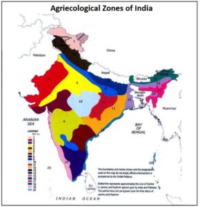
Map 1: Agroecological Zones of India, Source: FAO and The National Bureau of Soil Survey & Land Use Planning
Kulwinder Singh is an alumni of Jawaharlal Nehru University, New Delhi and working as Assistant Professor of Geography at Pt. C.L.S. Government College, Kurukshetra University. He is a passionate teacher and avid learner.