Aerial photography is the science and technology of capturing photos of the land surface from air. The product of aerial photography is an aerial photograph which refers to a large scale photo captured from a camera attached to any flying machine. The flying machine may be a helicopter, aeroplane, drone, etc. There are many Uses and Advantages of Aerial Photographs. A researcher or student must understand the various aspects of geometry of aerial photography for proper utilization of aerial photographs.
Geometry of Aerial Photography
Geometry refers to the science of measuring size, shape, orientation, inclination and volume of various physical or hypothetical objects.
- Similarly, the geometry of aerial photography refers to measurement of different aspects of objects on an aerial photograph.
- However, we can not measure any object on an aerial photograph until we understand the following concepts.
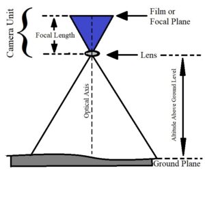
1. Film Plane or Focal Plane
- Film plane or focal plane is the surface in the camera on which the captured photo is imprinted. It is also known as the negative or focal plane.
- Before the advent of digital cameras, we all used such Roll Film (Fig. 1).
- For aerial photography, the surveyors use high sensitivity films with a wavelength of 0-3 to 0-9 µm wavelength.
2. Lens
- The lens is transparent part of the camera which captures the light coming from the ground and focusses it on the negative or film of the camera (Fig. 1).
- There are two types of cameras i.e. single lens cameras and multi-lens cameras.
- Single lens camera provide mosaic photos while the multi-lens camera provides timetrogon, sonne and composite aerial photo.
3. Focal Length
- Focal length refers to the distance between the film plane and the camera lens (Fig. 1).
- Different lenses have different focal lengths.
- The lenses with greater focal length have narrower view but more clarity. Contrarily, the lenses with lesser focal length captures wider view but with lesser clarity than the greater focal length lenses.
- Therefore, a researcher must choose the lens which fulfils the requirement of the study.
4. Ground Plane
- The ground plane is the earth surface which is being captured by the camera. It is the lowest point on the surface under consideration (Fig. 1).
- It is also known as positive.
5. Nadir
- Nadir is the point in the center of the film plane directly above the center of the ground plane in a vertical aerial photograph.
- In aerial photos, it denotes the center of the photograph.
6. Optical Axis
- Optical axis is the line joining the center of the film plane with the center of the lens of the camera and touches the ground plane (Fig. 1).
- The angle of the optical axis in relation to ground determines the shape of the objects in the aerial photographs.
7. Altitude Above Ground Level (AGL)
- As the term suggests itself, altitude above ground level (AGL) is the distance between ground plane and the film plane (Fig. 1).
- Usually, the surveyors attach the camera on the lower part of the airplane. So, one should not include the height of an airplane while calculating the altitude of an aerial photograph.
8. Scale of Aerial Photograph
- The scale of an aerial photo is the proportion of distance between two points on an aerial photo (Dp) and the actual distance between the same two points on the ground (Dg).
- We can write it as – Scale of AP = Dp/Dg.
- There are three Method of Calculating the Scale of Aerial Photographs.
- The knowledge of scale is important in measurement of size of different areas and objects on the ground.
9. Orientation of Aerial Photograph
- The angle of camera in relation to ground plane determines the orientation and shape of objects in the aerial photography.
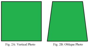
Fig. 2: Shape of objects in Vertical and Oblique Photo - The objects in a vertical photo will appear similar to their actual shape while the objects in oblique photos will show skewed shape (Fig. 2A and 2B).
- A square will look perfectly like a square in a vertical photo while in an oblique photo it will become broader near the camera and narrower away from the camera.
10. Projection of Aerial Photograph
- The aerial camera uses central projection for capturing photographs. The lens in an aerial camera device focuses the image of an object at a single point and then disperses it on the film or negative.
- Hence, in the central projection, the objects become a little skewed away from the center of the photograph but it is not very significant.
Conclusion
For using aerial photography, a complete understanding of the above concepts is necessary. These concepts also help us to identify features and interpret the aerial photo correctly.

Dr. Nisha Singh is a PhD from the Center for the Study of Regional Development, Jawaharlal Nehru University, New Delhi. She has six years of experience as an Assistant Professor of Geography at Kamala Nehru College, University of Delhi.