In the Introduction to Aerial Photography, we discussed the basic concept of aerial photography along with its characteristics, advantages and uses. However, aerial photographs are of various types. Different types of photographs have different merits and demerits. Hence, a researcher must know the various types of aerial photography to be able to use aerial photos according to the purpose of the research. The aerial photographs are classified on different grounds i.e. scale of aerial photograph, angle of optical axis, number of lenses in camera etc. This article will discuss these types in different sections.
On the Basis of Scale of Aerial Photograph
The Scale of Aerial Photograph refers to the ratio of distance between two points on the aerial photo and the same distance on the ground (actual distance). We can express this with the help of a formula.
Scale of Aerial Photograph = Distance on Aerial Photo ÷ Distance of Ground
For instance, if the distance between two points on aerial photographs is 10 CM and actual distance between these two cities on ground is 2 Kms., then the scale will be 10/2 Kms. = 10/200000 = 1/20000. Hence, the scale will be 1:20000. It means one centimeter on an aerial photo equals the 20000 centimeter on the ground.
Generally, aerial photos are classified into the following three types based on the scale.
- Large Scale: These are the aerial photographs which provide the maximum information about the landscape. They generally have a representative fraction of 1:15,000.
- Medium Scale: These aerial photographs have a representative fraction between 1:15,000 to 1:30,000.
- Small Scale: These aerial photographs have a representative fraction of more than 1:30,000.
On the Basis of Tilt of Optical Axis
The optical axis refers to the line joining the center of the film plane with the center of the lens of the camera and extends up to the ground plane. For details, read Geometry of Aerial Photography. The angle of the optical axis in relation to the earth surface determines the skewness in the shape of objects in the aerial photographs. Based on the tilt of the optical axis, we can classify the aerial photographs into three types.
1. Vertical Photograph
- Vertical photographs are captured when the optical axis is near perpendicular to ground (Fig. 1-A).
- Due to weather conditions and air turbulence, the angle of the optical axis may deviate up to 3 degrees from the perpendicular.
- In these photos, the shape of objects remains mostly in their actual state as visible from above. The error in the shape of objects may increase from center of the photo towards the edges but the error is insignificant.

Fig. 1: Angle of Optical Axis in Aerial Photography
2. Oblique Photograph
- Contrary to vertical photographs, the oblique photos are taken from an angle of more or less than 90 degrees (Fig. 1).
- Therefore, we can clearly notice the distortion in the shape of objects in the oblique photos.
- The objects which are near to the camera look larger whereas the objects away from the camera look smaller to their true shape and size.
- Hence, comparing one object to another becomes different.
- There are two types of oblique photos.
-
- Low Oblique Photographs: These photographs are taken by tilting the optical axis at an angle of less than 30 degrees (Fig. 1-B).
- High Oblique Photographs: These photos are taken by tilting the optical axis at an angle between 30 to 60 degrees (Fig. 1-C).
- The distortion or skewness in the shape and size of objects is higher in the high oblique photographs in comparison to low oblique photographs.
- Although it seems that vertical photographs are more appropriate for collection of spatial information, it all depends on the purpose of the study. A vertical photograph captures less area than an oblique photograph.
- Hence, if you need to capture more area in one photo and shape of the objects is unimportant then you may choose the oblique photos.
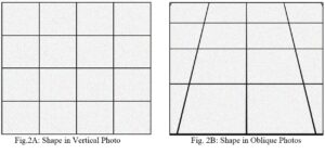
Fig. 2: Shape of Objects in Aerial Photographs
On the Basis of Type of Lens
The types of camera and number of lenses in camera affect the final aerial photograph. They are primarily of tow types i.e. single lens and multi-lens cameras.
1. Single Lens Camera
- Single lens camera captures the images of ground from one single optical angle.
- Therefore, the amount of distortion and details are uniform throughout the picture.
- Vertical and Oblique photographs are examples of single lens cameras.
2. Sonne Photograph
- Sonne photograph is a peculiar type of aerial photograph. These are the parts of a continuous and long strip of land. It is captured by using a single lens camera.
- The single lens camera captures the photos of a long strip of land at regular intervals.
- The speed of clicking photos and the rotation of the negative roll is adjusted according to the height and speed of the airplane or drone.
- As a result, the negative yields a continuous series of photos of a continuous terrain.
- These photos are termed as Sonne photographs.
3. Multi-lens Camera
- Contrary to single lens cameras, the multi-lens cameras are able to capture the photo of the earth surface from various optical angles.
- The various angles are only possible because the lenses in the camera device are arranged in such a manner that they capture the photos of objects on ground from different angles.
- Multi-lens cameras produce the following types of photographs.
- Composite Photograph: Three or more separate negatives are used simultaneously by a multi-lens camera. In a three lens camera, one camera takes a vertical photograph while the two lenses point outwards and take the oblique photos on both sides of the vertical camera. All three lenses are attached to a single camera on an airplane. The three negatives are overlapped and the resulting photograph is printed on the same plane. The resulting photo covers a wide area of the ground. In the modern world, the use of wide angle cameras lead to decline in the use of multi-lens cameras.
- Trimetrogon Photograph: Trimetrogon is similar to composite photographs. However, the key difference is that we do not combine the negatives and print overlapping images. In this case, the resultant photo shows the area from horizon to horizon on both sides of the camera. This uses three lenses to take three simultaneous photographs from different angles, allowing for a wide-angle panoramic view. However, the surveyors print these images in conjunction with each other. The resulting image shows a long strip of ground on the aerial photograph.
Conclusion
In short, we can conclude that the aerial photographs are of different types based on scale, angle of optical axis and number of lenses. Each type of photo has certain merits and demerits. Hence, the researcher must know these peculiarities of different types of photos to use the aerial photography efficiently and economically.
Kulwinder Singh is an alumni of Jawaharlal Nehru University, New Delhi and working as Assistant Professor of Geography at Pt. C.L.S. Government College, Kurukshetra University. He is a passionate teacher and avid learner.