Aerial photography is the science and technology of capturing photos of the land surface from any flying object such as airplane, helicopter, drone etc. Gaspar Felix Tournachon was first first person to capture an aerial photograph in 1858 from an air balloon. However, Talbert Abrams is known as the father of Aerial Photography. He was a pilot with the US Marine Corps and took widespread aerial photography. Afterwards, aerial photography became an important source of information. Therefore a researcher must understand the nature of aerial photography and their usage. In this article, we will provide a brief introduction to aerial photography and try to understand the definition of aerial photographs, its characteristics, advantages and uses.
Definition of Aerial Photograph
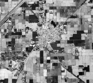
- Definition: An aerial photograph refers to a large scale photo captured from a camera attached to any flying machine. The flying machine may be helicopter, aeroplane, drone, etc.
- The large scale photographs show a small area on a piece of paper with great details.
- The scale of the photograph depends on the altitude of the aeroplane. On the one hand, if the aeroplane is taking the photo from higher altitude, the scale becomes smaller. On the contrary, if the aeroplane is taking the photo from lower altitude the scale becomes larger.
- Also read Types of Aerial Phtography.
Characteristics of Aerial Photographs
Aerial photographs have certain features which differentiate the from the other types of imageries and photos.
- Aerial photographs are a qualitative source of information.
- The aerial photos are generally large scale photos with a scale less than 1:30000. Hence, we can see the objects on the ground in great detail. The general maps do not show such characteristics on the ground.
- The aerial photographs are taken by precision cameras, therefore, errors are minimized while capturing photos from a flying object.
- Aerial camera devices have very high sensitivity and capture a greater range of information than the human eye. Human eye can capture the light with a wavelength of 0.4 to 0.7 micrometers whereas the aerial camera can capture the wavelength of 0.3 to 0.9 micrometer. Hence, we receive a greater amount of information.
- The aerial photos show the objects in their true shape and size, hence, it is easier for the humans to analyze an area without the help of a computer.
Advantages of Aerial Photography
- Improved Vantage Point: Aerial photos provide us with a bird’s view perspective. We can see a large area and its features in relation to each other.
- Historical Record: These photos show the real-time situation of a place at a particular time. Therefore, they become a historical record and we can use them to study past characteristics of land-use.
- Greater Information: The aerial photos capture a greater range of electromagnetic spectrum. Therefore, aerial photos show even those features of earth which can not be seen by human eye.
- Three Dimensional Views: A single aerial photo shows any given feature from two different angles. Therefore, we can see that particular feature in three dimensions with the help of a Pocket Stereoscope.
Uses of Aerial Photography
Like any other source of information, we use aerial photography for many purposes as follows.
- Reconnaissance Survey: These are also called preliminary surveys. These surveys are extensive study of an area before implementation of a project in that area. For example, before building an airport in an area, the planners will try to assess the availability of plain area, topographical barriers, presence of rivers etc. to see feasibility of an airport.
- Photogrammetry: It refers to the science and technology of making correct estimation of shape, size and altitude of objects on aerial photographs. Using photogrammetry, the cartographers use aerial photography for topographical mapping. The aerial photographs show topographical features in three dimensional view. We can compute the altitude of each and every object in aerial photography by using Stereo Micrometer or stereoscopy. Ultimately, we can draw the contours based on measurements through stereo micrometer.
- Making Topographical Maps: The cartographers use the aerial photographs to draw Topographic Maps. Topographical maps show the objects on the ground in representative colors e.g. water bodies in blue, forests in green etc. Topographical maps are of great importance for planning and implementation of policies.
- Interpretation of Aerial Photo: By interpretation of aerial photograph’s features, we can have a general understanding of the study area. For instance, if the farms in aerial photos look as white squares, it means the area is unirrigated. Similarly, by studying the shadow of objects, we can understand the topographic undulations in the area. The interpretation of aerial photographs provides important qualitative information about an area.
- Micro-level Planning: Since, the aerial photos are large scale images, the planners can plan at micro level. They may plan for very small objects such as trees, houses, ponds etc. before planning and executing a project.
Conclusion
In summary, we can conclude that aerial photography is a quick and effective visual tool to collect and analyze information. The aerial photographs are large scale, so it shows smaller objects in great detail. Further, it is a qualitative source of information and helps in efficient execution of projects of socio-economic welfare over the focus area.
Kulwinder Singh is an alumni of Jawaharlal Nehru University, New Delhi and working as Assistant Professor of Geography at Pt. C.L.S. Government College, Kurukshetra University. He is a passionate teacher and avid learner.