We need to understand different types of lapse rates to satisfy a curious person who might ask for the reason of rainfall. “Why does it rain?”
To answer this simple question, we must understand that the temperature of air declines as it rises from the earth surface towards higher altitude.
The curious mind will again ask, “Why does the rising air cool down? And why does the cooling of air cause rain?
To answer this, we need to understand the three types of lapse rates of temperature i.e. 1) Normal Lapse Rate or Environmental Lapse Rate 2) Dry Adiabatic Lapse Rate and 3) Wet Adiabatic Lapse Rate. Lapse rate means the rate of decline.
What is an adiabatic change in temperature?
The change in temperature of any parcel of air due to change in pressure is called adiabatic change in temperature. The beginners must read Adiabatic Change in Temperature first before proceeding.
Normal Lapse Rate or Environmental Lapse Rate
Suppose you are superman! If you fly from the earth’s surface towards clouds, you will feel that the air is becoming cooler and temperature declines. The air is warmer near earth’s surface because the air near earth’s surface is denser and absorbs more outgoing longwave earth radiation. As we fly higher, we will experience that the air becomes less dense and absorbs lesser outgoing earth radiation. Hence, the superman will experience cooler temperatures at higher altitude than the lower altitude. The rate of decline in temperature as we go higher is called Normal/Environmental Lapse Rate. This rate is 6.5°Celsius per kilometer. If the temperature in Delhi is 40°C in May and if the superman flies 2 Kms. up in the air, he will experience 27°C of temperature. This temperature change is purely due to differences in absorption of outgoing earth radiation and density of air between higher and lower altitudes. The Adiabatic cooling of air works differently. There are two types of adiabatic lapse rates i.e. Dry adiabatic and wet adiabatic lapse rates.
Dry Adiabatic Lapse Rate
When the heated air from near the earth’s surface rises above, it is dry and the water vapors are in gaseous form. As the parcel of warm air rises towards higher altitude, it starts to get cooler. The air expands because the atmospheric pressure is lower in the higher altitude than the lower altitude. The rate of cooling of rising dry air is called dry adiabatic lapse rate which is about 10°C/Km. Keep in mind that the air becomes cool just due to work of expansion, there is no exchange of heat between rising parcels of air and surrounding air. At a certain height, the water vapor in the dry air condenses and forms small droplets. Hence, the air becomes wet.
Wet Adiabatic Lapse Rate
After condensation of water vapor, the air continues to rise and atmospheric pressure continues to fall which leads to further cooling of wet air but at a lower rate i.e. 5.5°C/Km approx. This rate of cooling of wet air is called Wet Adiabatic Lapse Rate.
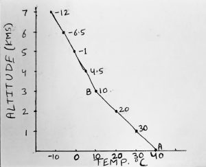
In Fig. 1, you can see that the air near earth’s surface is about 40C and temperature declines as we go up from point A to point B at 10C which is dry adiabatic lapse rate. Above Point B which is 3 Kms. high from ground, the water vapor in air condenses and there onwards, temperature declines at 5.5C up to height of 7 Kms.
So, why does it rain?
The water vapor in the air condenses into droplets due to adiabatic lapse rate of temperature. These water droplets coalesce to form larger droplets and are visible as clouds. The buoyant force of rising air is unable to sustain the weight of these droplets and subsequently, these droplets fall as rain. The water droplets freeze, melt, refreeze while on way to earth surface and cause different types of precipitation i.e. snow, hail, rain etc. For types of rain/precipitation, click here
Kulwinder Singh is an alumni of Jawaharlal Nehru University, New Delhi and working as Assistant Professor of Geography at Pt. C.L.S. Government College, Kurukshetra University. He is a passionate teacher and avid learner.