In Remote Sensing, the image resolution refers to the amount of information available in a satellite imagery. There is four types of resolution in satellite imageries i.e. Spatial, Spectral, Radiometric and Temporal resolutions. These four types of resolution in remote sensing determine the amount and quality of information in an imagery.
1. Spatial Resolution
- Spatial resolution refers to the clarity of features on the earth surface. Therefore, it is the ability of the sensor to differentiate between various objects and features of the earth surface.
- In simple words, spatial resolution refers to the ratio between size of pixel and the area it represents.
- The clarity of features on earth’s surface depends on the size of the pixel and the number of pixels in a given imagery.
- Please note that one pixel can be attributed to only one color. Therefore, if one pixel in an imagery represents a large area of the land, then the pixel will hide smaller details of that large area.
- Let us understand with the help of an example. Suppose that there is a one square kilometer area which is composed of 40 forests, 30 percent urban area, 20 percent water bodies and 10 percent other uses. In this case, if one pixel in imagery represents one square kilometer then the given area of one square kilometer will be shown as forest area (Fig. 1B). It is so because the forest area is the largest area. Further, the imagery will not be able to differentiate between urban areas, water bodies and other uses within that area of one square kilometer.
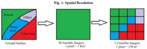
- Contrarily, if the size of the pixel is 250 square meters, then there will be 16 smaller pixels in the imagery which will present a detailed picture of the land-use. The imagery with smaller pixel size in Fig. 1C covers all types of land use.
- If we reduce the size of pixels in a given imagery, the number of pixels in that imagery increases. Higher number and smaller size of pixels means higher spatial resolution and vice-versa.
- The use of imageries of different pixel sizes depends on purpose. For instance, the climatologists need 2-5 Kms. of spatial resolution for studying global warming whereas defense establishments need 1 meter spatial resolution for public safety.
2. Spectral Resolution
- The amount of information in satellite imagery is also determined by the number of wavelengths which can be sensed by the sensor of the satellite camera.
- Therefore, if a sensor is able to sense greater number of wavelengths of electromagnetic spectrum, it will capture greater details of land-use and land cover.
- For example, if we use only the visible spectrum, we can only see those features of earth which are visible to human eyes e.g. presence of iron ore in soil whereas we will not be able to find other important minerals. However, by using the gamma ray spectrum, we will be able to locate potassium, uranium and thorium. Similarly, the infrared spectrum is unique for studying heat signatures of objects.
- In simple words, greater the number of spectrums in a satellite imagery means greater spectral resolution and vice-versa.
- There are three Types of Imageries in Remote Sensing based on Spectral Resolution i.e. Mono-spectral, Multi-spectral and Hyper-spectral imageries.
3. Radiometric Resolution
- Radiometric resolution refers to the ability of a sensor to capture the minute differences in the radiated energy from the earth surface.
- In other words, it is the number of shades of a grayscale in the pixels of a given satellite imagery.
- The number of shades of grayscale in a given pixel is measured in bits. The satellite imageries are available in 1 bit, 2 bits, 4 bits, 8 bits data and so on.
- A 1 bit imagery means that the number of colors in the imagery may be 2^1 = 2 i.e. black and white. Similarly, a 4 bit data means that the number of shades in a pixel of the imagery may be 2^4 = 16. Similarly, 8 bits means 256 digital values or shades.
 Fig. 2: Radiometric Resolution
Source: https://www.earthdata.nasa.gov/
- So, if we are using any specific band of spectrum, say near infrared, the sensor will be able to store 256 types of energy in that band.
- In Fig. 2 one can easily differentiate between a 2 bit and 4 bit imagery. The four bit imagery shows the tree cover, pathways and settlements clearer than the two bit imagery.
4. Temporal Resolution
- Temporal resolution refers to the amount of information available over a given time period.
- It is the revisit time of a satellite over a certain area. In other words, temporal resolution means the frequency of capturing images of a certain area by the satellite in a given time period.
- The availability of information over a given time period depends on the frequency of rotation of a satellite around earth.
- If a satellite comes over a specific area 2 times a day, its temporal resolution will be 12 hours. Similarly, if the satellite revisits a specific area every hour, its temporal resolution will be 1 hour.
- Temporal resolution is important to understand the direction and amount of change of phenomena in the study area.
- Land-use analysis needs monthly or yearly temporal resolution because land use changes slowly whereas disaster management needs hourly temporal resolution because disasters occur very fast and need regular monitoring.
Conclusion
In short, we can conclude that the resolution represents the amount of information in a given imagery. This information is in the form of pixels, colors and wavelengths captured over a given period of time. The greater number of pixels, colors and wavelengths in an imagery provides us more information and visual clarity and vice-versa.
Kulwinder Singh is an alumni of Jawaharlal Nehru University, New Delhi and working as Assistant Professor of Geography at Pt. C.L.S. Government College, Kurukshetra University. He is a passionate teacher and avid learner.