Topographical Sheets
Topographical sheets or topo sheets are large scale maps of land area of the world.
- Large scale means that smaller area is shown in detail on a piece of paper. Here, the representative fraction is small e.g. 1:25000.
- Small scale means that large area is shown on a piece of paper but it misses on detailed information. Here, the representative fraction is large e.g. 1:1000000.
- Topographical sheets contain detailed information about the area under consideration.
- It shows both natural and socio-economic landscape in detail.
- The natural landscape includes forests, slope, undulations, hills, passes, peaks etc. with the help of contour and different color schemes.
- The socio-economic landscape includes villages, homes, temples, railways, roadways, hospitals, police stations, post offices etc. with the help of colors and conventional symbols.
- Click Here for Example of Topo Sheet.
Types of Topographical Sheets
Based on scale of map, the topographical sheets are classified into following types.
- The whole world is divided into degrees by latitude and longitudes.
- Based on the degrees covered by topographical sheets, they are divided into 4×4 degree topo sheets, 1 Degree topo sheets, Half Degree topo sheets, Quarter Degree topo sheets and new series topo sheets.
- This numbering of these topo sheets is based on Everest and Polyconic Projections.
- As we move from 4×4 degree topo sheets to quarter degree topo sheets, the RF becomes smaller and smaller.
1. 4×4 Degree or Million Sheets
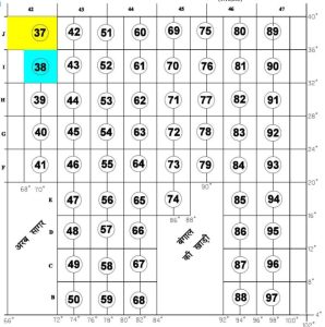
- This series of topo sheets cover an area spanning 4° Latitudes and 4° Longitudes (Fig.1).
- It has a scale of 1:10,00,000.
- They are numbered as 1,2,3,4,5……etc. For example, 53 number sheet envelops areas of Karnal district of Haryana and Western Uttar Pradesh.
- It is a small scale map and shows considerably large area on a piece of paper.
- The contour interval is 500 meters.
- India and its adjacent countries are covered by 136 such million sheets.
- It covers almost 40 degrees of longitudes and latitudes.
- Since, these maps do not show detailed information, its publication has been discontinued as a topo sheet.
2. One Degree Topo Sheets
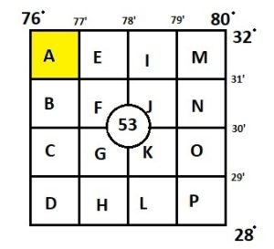
- Each Million sheets contains 16 One Degree topo sheets.
- This series of topo sheets cover an area spanning 1° Latitudes and 1° Longitudes within 4×4 degree topo sheets. (Fig.2)
- They are numbered as A,B,C,D,E…..etc. within million sheets. In 53 number sheet, there would be 16 more sheets numbered as 53A, 53B, 53C…..53P.
- It has scale of 1:250000.
- The contour interval is 250 meters.
3. Half Degree Topo Sheets
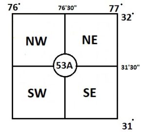
- This series of topo sheets cover an area spanning 1/2° Latitudes (30 minutes) and 1/2° Longitudes (30 minutes) within one degree topo sheets (Fig.3).
- There are four Half Degree Sheets within One Degree Sheets having area of 30 minutes latitude and longitude.
- They are numbered as 53 A/NE, 53 A/NW, 53 A/SE and 53 A/SW.
- It has a scale of 1:125000.
- It has contour interval of 100 meters.
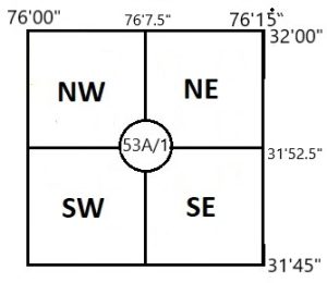
4. Quarter Degree Topo Sheets
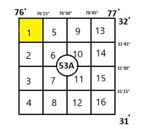
- This series of topo sheets cover an area spanning 1/4° Latitudes (15 minutes) and 1/4° Longitudes (15 minutes) within one degree topo sheets (Fig.4).
- There are 16 Quarter Degree Sheets within One Degree Sheets having area of 15 minutes latitude and longitude.
- They are numbered as 53 A/1, 53 A/2, 53 A/3, 53 A/4, 53 A/5…….53 A/16.
- It has a scale of 1:50000.
- It has contour interval of 50 meters.
5. New Series Topo Sheets
- This series of topo sheets cover an area spanning 1/8° Latitudes (7.5 minutes) and 1/8° Longitudes (7.5 minutes) within quarter degree topo sheets.
- When Quarter Degree Sheet is divided into 4 equal parts or 6 unequal parts, we get very large scale topo sheets with lots of information.
- They are numbered as 53A 1/NE, 53A 1/NW, 53A 1/SE, and 53A 1/SW.
- It has a scale of 1:25000.
- It has contour interval between 5-20 meters depending on purpose and area. For example, the mountainous area has higher elevation and contour interval should be little larger. Whereas, the contour interval in plain areas should be smaller.
For accessing topographical sheets of India, CLICK HERE.
It must be understood that the scale of topo sheet is determined based on our goals and uses. It someone does not need very detailed information, they might use 1:250000 scale maps. Whereas for detailed information, one may use 1:25000 scale maps.
Kulwinder Singh is an alumni of Jawaharlal Nehru University, New Delhi and working as Assistant Professor of Geography at Pt. C.L.S. Government College, Kurukshetra University. He is a passionate teacher and avid learner.