Survey of India’s Topographical Sheets
East India Company established Survey of India in 1767 for mapping, survey and exploration of resources in India. It publishes the topographical sheets in two series i.e. open series maps and defense series maps.
Open Series Maps
- Survey of India prepares these sheets on 1:250000, 1:50000 and 1:25000 scale as shown in Fig.1.
- Open Series Maps are numbered differently than the Everest and Polyconic Projection numbering as explained in our article “Topographical Sheets: Types and Uses.”
- These are based on WGS-84 Datum and UTM Projection as shown in Fig.
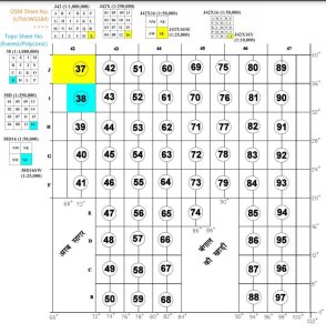
Fig.1: Numbering and Indexing of Open Series Maps by Survey of India - They do not contain grid lines. They also do not contain the classified information due to national security reasons.
- Therefore, these are open series and unrestricted maps.
Defense Series Maps
- These maps are also prepared on 1:250000, 1:50000 and 1:25000 scale.
- These are based on WGS-84 and Lambert Conformal Conical Projection
- They contain detailed and classified information.
- Hence, these maps have restricted access and are not available to public.
For downloading topographical sheets of India, CLICK HERE.
The scale of topo sheet is determined based on our goals and uses. If someone does not need very detailed information, they might use 1:250000 scale maps. Whereas for detailed information, one may use 1:25000 scale maps.
Kulwinder Singh is an alumni of Jawaharlal Nehru University, New Delhi and working as Assistant Professor of Geography at Pt. C.L.S. Government College, Kurukshetra University. He is a passionate teacher and avid learner.