Deccan Plateau is a plateau in Southern India with an average elevation of 600 Meters from the sea level and area of 800,000 square kilometers. Deccan Plateau is located in the peninsular part of plateau. Eastern Ghats and Western Ghats forms its eastern and western borders on the east and the west, respectively. The River Narmada acts as its northern boundary. Deccan plateau map is complicated.
Formation of Deccan Plateau
- Deccan plateau is part of an ancient landmass called Gondwanaland. It is located to the south of Tropic of Cancer.
- During the Cretaceous Period, a fissure eruption lead to spread of lava over extensive area of southern India.
- The lava continued to upwell for 1 million years.
- Therefore, a large plateau with a depth of about 1-2 Kilometers was formed. We call it Deccan Plateau.
- Tectonic Activities: Due to tectonic activities, the western part of Indian peninsula went through emergence and eastern part subsided. Hence, the slope of deccan plateau is from west to east and most of river flow to Bay of Bengal.
- Presently, it looks like a table land. Eastern and Western Ghats form its boundaries and come across as steep hill when seen from sea shore.
Deccan Plateau Facts
- Maharashtra, Southern Chhattisgarh, Telangana, Karnataka, Andhra Pradesh and Northwestern Tamil Nadu contain most of Deccan plateau (see Fig. 1).
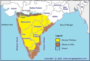
Fig. 1: Deccan Plateau Map - It is triangular in shape.
- Basalt forms its top layer with 1-2 kilometers of depth. The cooling of lava on the surface of the earth surface leads to formation of basaltic rocks.
- Over million of years, a lot of weathering and erosion has taken place on the deccan plateau which lead to formation of Black or Regur Soil.
- Black soil is good for cultivation of cotton and sugarcane because it can hold water for a long period of time.
- Deccan plateau has lots of large rivers such as Mahanadi, Godavari, Krishna and Kaveri. These rivers flow to the Bay of Bengal and form large deltas. These deltas are very fertile and good for cultivation.
- River Narmada and Tapti are only major rivers in the south which flow into Arabian Sea. These river flow through Rift Valleys.
- The western ghats are more continuous than the Eastern Ghats because the large southern rivers have eroded eastern ghats at multiple locations.
- Konkan coast is the northern coast of western ghats and Malabar is the southern coast of western ghats.
- Northern Circars is the northern coast of eastern ghats and Coromandal is the southern coast of the eastern ghats.
- Resource: There are large reserves of coal, iron, manganese, bauxite, natural gas etc. in deccan plateau.
Conclusion
- Deccan plateau is a large table land with lots of natural resource.
- Fissure volcanic eruption is the major reason of its formation, therefore, most of rocks in this region are igneous/basaltic.
- The general slope of this plateau is from northwest to southeast.
Kulwinder Singh is an alumni of Jawaharlal Nehru University, New Delhi and working as Assistant Professor of Geography at Pt. C.L.S. Government College, Kurukshetra University. He is a passionate teacher and avid learner.