There is primarily three types of rainfall based on the means of condensation of moisture in the air. The rising hot air cools at dry adiabatic and wet adiabatic lapse rate which leads to condensation of water vapor present in rising air at high altitude. Subsequently, the condensed water droplets coalesce to form larger water droplets. The buoyant force of rising air is unable to sustain the weight of bigger droplets, therefore, the condensed water starts to fall as rain.
There are three types of rainfall
1. Convective Rainfall
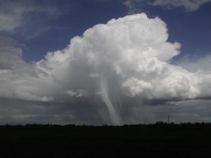
Initially, the earth’s surface is heated by incoming solar radiation. The earth’s surface heats the air near it. The heated air becomes lighter and starts to rise. This rising heated air is called convective currents and carries the evaporated water (vapor) from earth’s surface to the higher altitude. The air and water vapor present in air starts to cool down at dry adiabatic and wet adiabatic lapse rate which leads to condensation of water vapor and forms very high column of clouds looking like cauliflower (Fig.1). This leads to formation of thunderstorms and results in heavy rainfall with strong winds.
2. Orographic or mountainous Rainfall
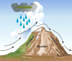
Oros means mountain. This rainfall is also caused by condensation of water vapor as stated above at dry adiabatic and wet adiabatic lapse rate but the mechanism of updraft of air is different. Here, a parcel of humid wind which is blowing horizontally collides with a physical barrier such as mountain/hill/plateau etc. the barrier forces the air to rise towards higher altitude which leads to cooling of air and condensation of water vapor, resulting in rainfall on windward side of mountain (Fig.2). The dry air flows downslopes on the leeward side of mountain and gets heated adiabatically due to increase in air pressure and causes desert like climate on leeward side.
3. Frontal Rainfall
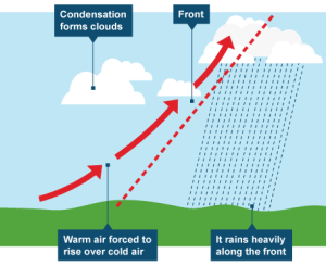
First we need to understand what is an air mass and front. An airmass is air over a large area having homogeneous properties such as same temperature, moisture, stability etc. When two air masses of different properties collide with each other, the resulting rainfall is called frontal rainfall. Let’s elaborate. One of these two air masses is warm, humid and lighter whereas the other is cold, dry and heavier. When these two air masses collide, the cold air mass pushes the warm air mass upwards as shown in the fig. 3. The moisture in the upward moving warm air mass condenses which results in rainfall. The boundary separating these two air masses is called a front (Fig.3). For detailed explanation, read Definition and Types of Air Masses and Frontal Cyclones.
What is Cloudburst?
Cloudbursts does not mean that the clouds literally fall apart and pour water stored above them. In fact, it is rainfall but the intensity of rainfall is very high. The size of raindrops is greater than 7.5 mm. When intensity of rainfall is very high, the soil is not able to absorb the rainwater and most of the water flows as runoff. This results in loss of life and causes immense damage to society, economy and biodiversity.
One may wonder, why does the intensity of rainfall become so high! Normally, when air is rising towards higher altitude due to mountain barrier, the water vapor condenses slowly as it rises higher and higher. The condensation lead to formation of clouds which shower rain over the whole slope of the mountain. When a steep slope forces very humid air upwards, the whole water vapor condenses suddenly and causes heavy rain (downpour) over a small area but in a short period of time. This phenomena is is known as cloudburst in common parlance. They happen, normally in mountainous areas of 2500 meters and above from the sea level.
Also Read: Difference between Rainfall and Precipitation.
Kulwinder Singh is an alumni of Jawaharlal Nehru University, New Delhi and working as Assistant Professor of Geography at Pt. C.L.S. Government College, Kurukshetra University. He is a passionate teacher and avid learner.