E.W. Burgess proposed the Concentric zone theory in 1925. This model is also known as ecological theory of city structure or urban morphology. The primary concern of this model was to map the urban social problem i.e. vices and crime in Chicago city. To map the vices and crimes, Burgess mapped the different zone of the Chicago. He found that the land-use around the Central Business District has concentric zones/pattern.
Concentric Zones in a City
Burgess classified the city space in five zones having different land-use and character.
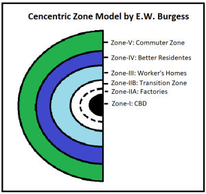
1. Zone-I: Central Business District
-
- This zone represents the Central Business District (CBD).
- It is the center of all high end commercial activities.
- So, the land rent in CBD is very high. Therefore, land use is very intensive.
- There are huge business offices and administrative building in this area.
- CBD has negligible residential areas.
- All the transport networks converge in this zone.
2. Zone-II: Transition Zone
-
- This zone is further bifurcated into two zones i.e. II-A and II-B.
- The II-A zone contains the old manufacturing units. The building are crowded and decaying in this zone. Due to presence of factories, this zone is highly polluted.
- The II-B zone is transition zone between factories and residential area. It is a zone characterized by mixed land-use. The housing condition in this zone is poor with lack of proper light and ventilation. It also contains some commercial activity. This zone has old crowded residences and factories which points towards decay of city.
- The people living in this zone can not afford commute due to low income. Therefore, they have to live very close to their workplace i.e. CBD and manufacturing zone.
3. Zone-III: Workers’ Homes
-
-
- This zone is zone of old and new construction. The living condition in this zone is modest.
- These houses belong to lower middle class, blue collared workers.
- This area has some older construction which needs redevelopment.
- The homes densely constructed to accommodate all workers.
- Since these worker can afford little commuting cost, they live relatively closer to the CBD.
-
4. Zone-IV: Better Residential Area
-
-
-
- This zone has the better residential properties occupied by mostly white collared workers.
- The income of the residents is very good, therefore, they can afford the housing in this zone.
- The properties in this zones are detached from each other.
- This zone is has open spaces such as parks, gardens and affluent markets.
-
-
5. Zone-V: Commuters’ Zone
-
- This is the farthest zone from the city and provide housing to wealthiest populace.
- These people can afford commuting to CBD due to their high income.
- It contains large spacious homes.
- The residential complexes in this zone is usually close to wide roads but there is scarcity of public transport which necessitates commuting by personal vehicles.
Criticism of Concentric Zone Model
- This model is based on one city of one country i.e. Chicago, USA. Therefore, it need not have universal application.
- The topography is not always isotropic, so, the zones may not be perfectly circular with constant width.
- This theory completely ignores the institutional interventions for the redevelopment of CBD and the transition zone. These days, the municipal corporations have redeveloped the transition zones into downtown having best clubs, restaurants, shopping complexes.
- This model also ignores the role of transport networks in the morphology of a city as explained in The Wedge Model. The commercial and industrial units tend to locate near large roads to import and export goods efficiently.
- This model neglects the industrial land use in and around city. It shows that there is a zone of decayed factories but does not elaborate the operation of other non-polluting industrial within the city.
Conclusion
This model points towards the decline in land use intensity as one moves away from the CBD. This is similar to Von Thunen Model on Land Use. Its application is not universal. This model is not applicable in Indian context.
Kulwinder Singh is an alumni of Jawaharlal Nehru University, New Delhi and working as Assistant Professor of Geography at Pt. C.L.S. Government College, Kurukshetra University. He is a passionate teacher and avid learner.