Every student in the world learns about latitude and longitude in their primary schools and think that these are permanent lines on the earth’s surface. Even adults do not fully understand the meaning and the uses of latitude and longitude. Therefore, we will try to understand the concept and definition of latitude and longitude in a very simple manner. Additionally, we will find the method of finding the latitude and longitude of any given place. Basically, latitudes and longitudes are imaginary lines on the surface of the earth which help us find the location of any person or object on the earth surface.
Important Terms Before Proceeding
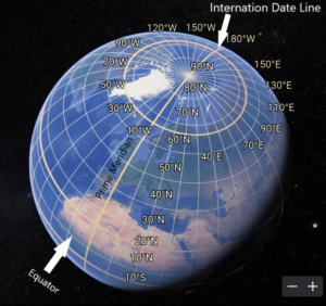
- Prime Meridian: Prime meridian is the line on the surface of the earth which joins north pole to south pole and passes through Greenwich in London. It divides the earth in two hemispheres i.e. eastern hemisphere and western hemisphere. It is also known as zero degree longitude.
- International Date Line: International date line is a line on the surface of the earth which joins the north pole to south pole and lies on the total opposite side of the prime meridian line. It is also known as 180 East and 180 West Longitude. However, it is not straight line due to administrative regions. There are 180 longitudes up to the international date line while moving from Prime meridian towards the east. Similarly, there are 180 longitudes up to the international date line while moving from Prime meridian towards the west.
- The Great Circle or Equator: It is a circle on the surface of the earth which intersects the prime meridian at 90° angle and divides the earth into two equal parts.
- Graticule: The latitudes and longitudes intersect each other and make a net like pattern over the earth surface. This net of latitudes and longitudes is called graticule.
What is Longitude?
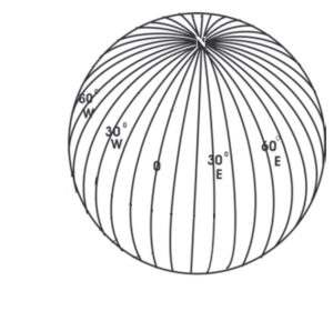
- Longitudes are imaginary vertical lines on the earth surface joining the north and south pole (Fig. 1 & 2).
- There are 360 longitudes on the earth surface which are measured in degrees e.g. 45° East or 45° West.
- Each longitude is divided into minutes and seconds e.g. 45° East, 4 minutes 24 seconds. We can write it as 45°4′ 24″E.
- Each longitude is of the same size.
- The distance between each longitude at the equator is about 111 kilometers which declines gradually towards the pole. All longitudes meet at poles.
- In short, longitudes divide the earth surface into 360 equal parts from east to west.
How to draw Longitudes?
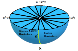
- Draw a line joining the north and south pole which should pass through Greenwich, United Kingdom. Mark the point where this line intersects the equator as 0 degree longitude (see yellow line in Fig. 3).
- Now, use a protector and divide the equator into equal 360 degrees starting from 0 degree longitude. There will be 180° latitudes to the east and 180° latitudes to the west (see fig. 1 & 3).
- The 180 degree East and West latitude is a single line which lies opposite to the prime meridian.
- Now join the north and south pole in such a manner that the lines should pass through 360 points on the equator of the earth.
- Ultimately, we get 360 degrees of longitudes (see fig. 2 & 3).
What is Latitude?
- Latitudes are the imaginary horizontal lines running parallel to the equator and divide the earth into 180 degrees (See Fig. 1).
- There are 90 degrees latitudes in the northern and southern hemisphere, each. The 90 degree latitude is just a point not a circle.
- Unlike longitudes, the size of each latitudinal circle becomes smaller as we observe from the equator towards the poles.
How to Draw Latitudes?
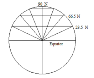
You can follow these steps to draw latitudes.
- Firstly, draw a line joining the north and south pole. This line is known as the axis of earth (Fig. 4).
- Secondly, draw a line perpendicular to the axis which divides the axis into equal parts. This line is known as the equator or great circle.
- Thirdly, draw angles by using the equator as the base towards the poles. The angles must not exceed 90 degrees for each hemisphere. Mark each degree.
- Lastly, draw the lines parallel to the equator from each marked degree.
- Through this process, we get a series of circles which represent the distance in degree from the equator of the earth.
- The absolute distance between each latitude is 111 Kilometers, approximately near the equator and declines to about 90 kilometers near the poles. This difference is due to the flattening of the shape of earth near the poles.
Difference Between Latitude and Longitude
It is clear from the discussion in the previous sections that latitudes and longitudes have many key differences. However, there is also difference in their use and application.
- Latitudes are horizontal lines and longitudes are vertical lines.
- Latitudes divides the earth into horizontal zones i.e. Tropical Region, Subtropical Region, Polar Region etc. whereas the longitudes divide the earth into vertical zones i.e. east and west.
- Latitudes convey the climatic conditions of a region whereas the longitudes may provide east-west variation of climate along a given latitude.
- We use longitudes to divide the world into different time zones.
- The length of the daylight varies seasonally from one latitude to another whereas longitudes do not define length of daylight.
How to Find Latitude and Longitude of a Place?
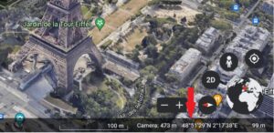
It is very easy to locate anything on the surface of earth. Let us take the example of Eiffel Tower in Paris. One has to visit Google Earth. Search the Eiffel Tower in search bar in the top left corner. Then you can zoom in on Eiffel tower. Lastly, when you place the mouse cursor on top of Eiffel Tower, you will be able to see the latitude and longitude information on the bottom right corner of the website (see Red arrow in Fig. 5).
Conclusion
In short, we may conclude that latitudes and longitudes are essential part of navigation and locational analysis. It is only with the help of latitudes and longitudes that locational analysis in geography and other social sciences is possible. Hence, a student must understand their actual meaning and application.
Kulwinder Singh is an alumni of Jawaharlal Nehru University, New Delhi and working as Assistant Professor of Geography at Pt. C.L.S. Government College, Kurukshetra University. He is a passionate teacher and avid learner.
